Serving Gogebic, Iron and Ontonagon Counties
Serving Gogebic, Iron and Ontonagon Counties
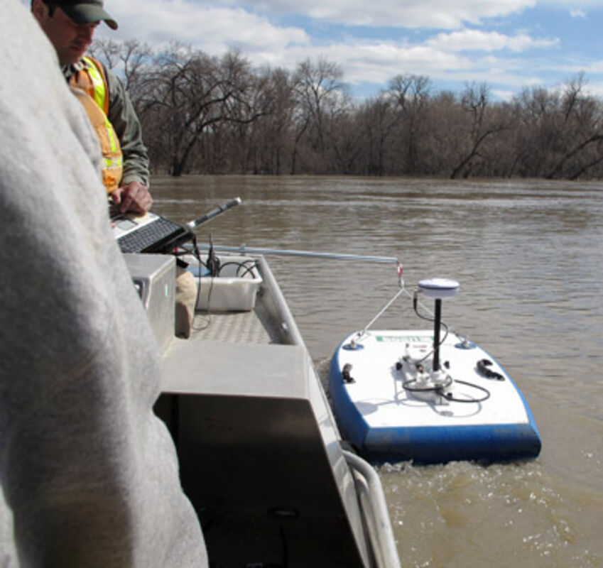
a device called an acoustic Doppler current profiler is tethered to the side of a boat and used to take stream flow measurements and river depth readings on the Red River in Fargo, N.D. in April 2013. Even with reams of data, forecasting a flood is still an imprecise science.
FARGO, N.D. (AP) — Perched in a boat drifting slowly along the Red River, Dan Thomas kept one eye on a laptop and the other on a $60,000 piece of floating hardware that beamed sound waves deep into the flooding river. As the signal bounced off water molecules and returned, the laptop sorted it into data on the river’s depth and speed and transmitted it instantly to the National Weather Service.
Once there, the work by the U.S. Geological Survey’s water expert became part of the data stew the weather service relies upon to regularly update crest projections for rivers like the Red, which rose again this spring to briefly threaten Fargo and neighboring Moorhead, Minn. And the complexity of the science was never more evident than this year, when an early forecast of 40 feet prompted costly sandbagging only to be repeatedly revised downward until the Red barely broke a harmless 33 feet.
The apparent false alarm irritated some residents who questioned why the city spent $2 million preparing for the flood that wasn’t. And that irritated Fargo Mayor Dennis Walaker, who has sparred with the weather service himself in the past.
“They all become experts,” Walaker said. “You can’t believe how many times I get stopped throughout the day by people who tell me the water is not going to get to a certain level.”
Greg Gust, the weather service’s warning coordination meteorologist in Grand Forks, acknowledged the agency had heard criticism of its projections for Fargo. He said it is constantly studying ways to improve its performance, but will always have limitations.
“Many times the weather service is being asked to do the impossible,” Gust said. “We’re being asked to forecast an unknown situation out into the future. We don’t have a perfect knowledge what’s going on today in the system, and yet we’re supposed to be able to forecast some unknown point in the future where clearly we have no knowledge.
“That said, that’s the task of a forecaster.”
Flood fights have become routine on the Red River at Fargo, but this one came nearly a month later than ever before due to winter conditions that refused to loosen their grip.
“We don’t have anything to go on when these things go on so late,” Steve Buan, a weather service hydrologist who works on river forecasts in the region, lamented as the Red was rising.
Flood forecasting in this part of the continent starts with models for determining how much snow is on the ground. Observers record every snowfall. But it’s even more important to figure out how much water is in that snowpack, which requires melting samples. It can also be done by going airborne to measure the natural radiation coming from the soil — a factor affected by the water in the snowpack.
Next up is more modeling on what will happen when the snow melts, which includes a dizzying number of variables. Is the ground frozen? How deep? How much moisture is in the soil?
Months of drought worked in Fargo’s favor this year. So did a freeze-thaw cycle that melted snow and warmed the soil during the day — giving runoff a place to go — and then slowed or stopped the melting overnight.
Weather service hydrologists get data on snow depth, water content, frost depths and soil moisture levels from many different sources, including their network of observers. That network has been bolstered in the Red River Valley over the last couple years by several high schools and middle schools participating in the River Watch program of the Fargo-based International Water Institute.
The students melt snow samples to see how much water is in their local snowpack, institute director Chuck Fritz said. They use frost tubes placed in the ground that contain chemicals that change color to show how deep the frost goes. And they use infiltration rings to measure how fast the ground can absorb water.
Wayne Goeken, a monitoring and education specialist with the institute, explained how infiltration rings work. They drive a 10-inch ring of PVC pipe about 2 inches into the ground in the fall. Then when the ground starts to thaw in the spring, students pour 4 inches of water into the ring and use a ruler to measure at one minute, three minutes, five minutes and longer intervals whether and how fast the water soaks into the ground. Then the schools feed that data to the weather service.
Forecasters run actual and predicted rainfall through their models, Buan said. They use more modeling tools for how the water will flow downstream. And they have to take into account potential changes in how much water is held back in reservoirs, such as Lake Traverse at the southern end of the Red River watershed.
Once forecasters have an idea of how much water is coming, their models also tell them about the relationship between the projected stream flows and how high the river will be at any given flow rate, which ultimately helps them predict how high the river will rise.
Most of those broad principles hold true for most river systems, Buan said. Perhaps the biggest difference between forecasting the Red and more southerly systems like the Mississippi’s is the need to account for frost in the ground in northern states and how it affects runoff rates, he said. The different topography is also a factor. The Red River Valley has almost no slope; the Mississippi has considerably more.