Serving Gogebic, Iron and Ontonagon Counties
Serving Gogebic, Iron and Ontonagon Counties
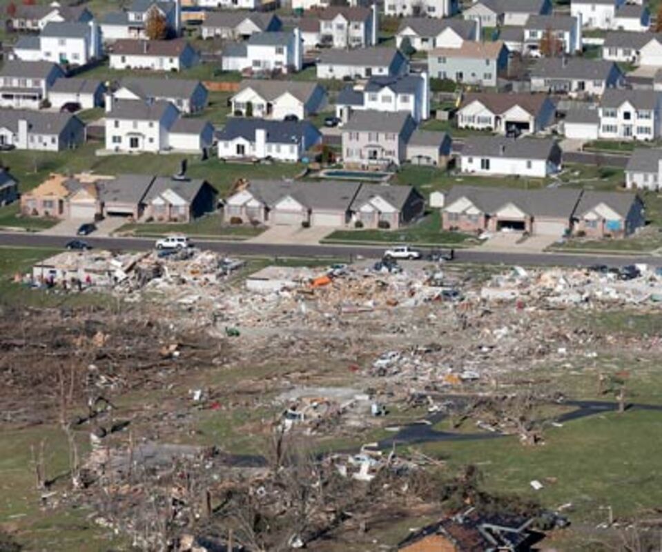
This aerial view on Monday shows untouched homes and homes destroyed by a tornado that hit the western Illinois town of Washington on Sunday. It was one of the worst-hit areas after intense storms and tornadoes swept through Illinois. The National Weather Service says the tornado that hit Washington had a preliminary rating of EF-4, meaning wind speeds of 170 mph to 190 mph.
WASHINGTON, Ill. (AP) - When a cluster of violent thunderstorms began marching across the Midwest, forecasters were able to draw a bright line on a map showing where the worst of the weather would go.
Their uncannily accurate predictions - combined with television and radio warnings, text-message alerts and storm sirens - almost certainly saved lives as rare late-season tornadoes dropped out of a dark autumn sky. Although the storms howled through 12 states and flattened entire neighborhoods within a matter of minutes, the number of dead stood at just eight.
By Monday, another, more prosaic reason for the relatively low death toll also came to light: In the hardest-hit town, many families were in church.
"I don't think we had one church damaged," said Gary Manier, mayor of Washington, Ill., a community of 16,000 about 140 miles southwest of Chicago.
The tornado cut a path about an eighth of a mile wide from one side of Washington to the other and damaged or destroyed as many as 500 homes. The heavy weather also battered parts of Michigan, Wisconsin, Iowa, Missouri, Indiana, Ohio, Kentucky, Tennessee, West Virginia, Pennsylvania and western New York.
Back in Washington, Daniel Bennett was officiating Sunday services before 600 to 700 people when he heard an electronic warning tone. Then another. And another.
"I'd say probably two dozen phones started going off in the service, and everybody started looking down," he said.
What they saw was a text message from the National Weather Service cautioning that a twister was in the area. Bennett stopped the service and ushered everyone to a safe place until the threat passed.
A day later, many townspeople said those messages helped minimize deaths and injuries.
"That's got to be connected," Bennett said. "The ability to get instant information."
In Indiana, Taylor Glenna heard emergency sirens go off and received an alert on his cellphone. A friend also called to warn him the storm was nearly upon him.
Glenna went outside, saw hail and heard a loud boom. He ran to his basement just in time.
On Monday, he was surveying the damage on crutches after suffering a leg injury when the wind knocked his home off its foundation.
"I would say we had pretty good warning," Glenna said. "We just didn't listen to it."
Forecasting has steadily improved with the arrival of faster, more powerful computers. Scientists are now better able to replicate atmospheric processes into mathematical equations.
In the last decade alone, forecasters have doubled the number of days in advance that weather experts can anticipate major storms, said Bill Bunting of the National Weather Service.
But Bunting, forecast operations chief of the service's Storm Prediction Center in Norman, Okla. said it was not until Saturday that the atmospheric instability that turns smaller storm system into larger, more menacing ones came into focus.
That's when information from weather stations, weather balloons, satellite imagery and radar suggested there was plenty of moisture - fuel for storms - making its way northeast from the Gulf of Mexico.
Despite Sunday's destruction, 2013 has been a relatively mild year for twisters in the U.S., with the number of tornadoes running at or near record lows.
So far this year, there have been 886 preliminary reports of tornadoes, compared with about 1,400 preliminary reports usually sent to the weather service by mid-November.
Similar slow years were 1987 and 1989.
An outbreak like the one that developed Sunday usually happens about once every seven to 10 years, according to tornado experts at the National Weather Service's Storm Prediction Center in Norman, Okla.
There were similar November outbreaks in 1992 and 2002, with the 1992 one being even bigger than this year's, said top tornado researcher Harold Brooks at the National Severe Storms Laboratory, also in Norman.
The storms erupted because of unusually warm moist air from Louisiana to Michigan that was then hit by an upper-level cold front. That crash of hot and cold, dry and wet, is what triggers twisters.
Like most November storms, this one was high in wind shear and lower in moist energy. Wind shear is the difference between winds at high altitude and wind near the surface.
Because it was high in wind shear, the storm system moved fast, like a speeding car, Brooks said. That meant the system hit more places before it petered out, affecting more people. But in places where it hit, the system may have been slightly less damaging because it was moving so fast, he said.
About 90 minutes after the tornado plowed through Washington, rain and high winds slammed into downtown Chicago, prompting officials at Soldier Field to evacuate the stands and order the Bears and Baltimore Ravens off the field. Fans were allowed back to their seats shortly after 2 p.m., and the game resumed after about a two-hour delay.