Serving Gogebic, Iron and Ontonagon Counties
Serving Gogebic, Iron and Ontonagon Counties
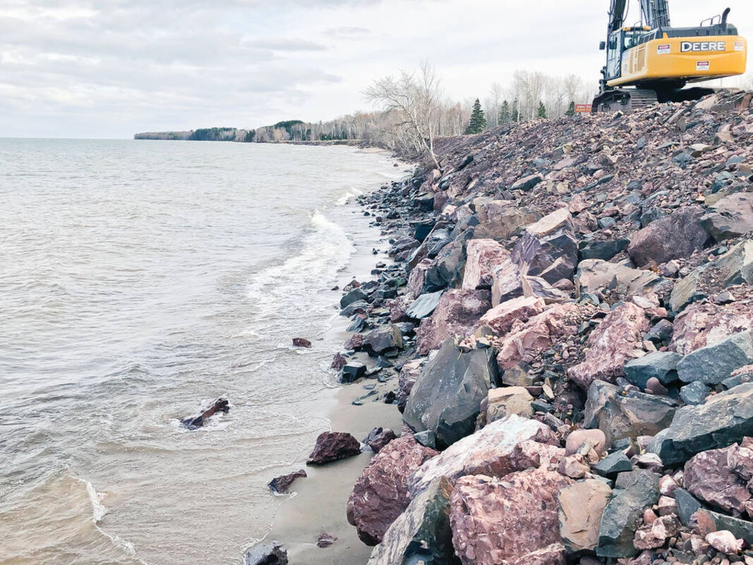
A recently completed stretch of County Road 107 shows armoring work in the form of large boulders placed to protect the shoreline and road from Lake Superior waves.
LANSING - The work to protect the main east access road to Porcupine Mountains Wilderness State Park is continuing in the face of violent late fall storms off Lake Superior.
County Road 107 will be closed west of South Boundary Road while work is underway. A search for a long-term solution to the problem continues.
The Michigan Department of Natural Resources and the Ontonagon County Road Commission have teamed up to protect County Road 107 to ensure continued east access to the 60,000-acre park and its signature attractions. The work started in August after storm erosion resulted in about 80% of the 1.6-mile stretch of affected county road having less than 20 feet of shoreline between the lake and the road. The DNR involved itself in the county road project because of the road's importance to the park.
"Without this main access way, should a road washout or undermining occur, visitors to the park's east end may be required to take an 80-mile detour, via west end entry, or be prevented altogether from reaching numerous points of interest," said Eric Cadeau, a regional planner with the DNR Parks and Recreation Division.
Some of those points of interest include the Lake of the Clouds overlook, Union Bay Campground and the park's ski area, he said.
"Access to the Lake of the Clouds and to the great resources of the Porcupine Mountains Wilderness State Park is critical for visitors and area tourism," said Ron Olson, division chief of DNR Parks and Recreation.
The DNR and road commission spent a combined total of $651,400 to place boulders and other protective measures between the county road and Lake Superior, he said. In places where the work was completed since August, the remedies have worked, he said.
"The storms we had around Thanksgiving battered the shoreline with high waves, but the work we did to armor the shoreline was effective in protecting the roadway," said John Pepin, DNR deputy public information officer. "In some other places nearby, unprotected areas, some erosion did occur to right up to the edge of the road."
The road commission immediately marked those areas with barrels to alert motorists of the hazard. Crews added materials to the roadside shoreline to mitigate wave damage.
The DNR is currently mobilizing excavators and other equipment along with procuring large ballast rock to extend the armoring project beyond what was finished last summer, said Mike Knack, park supervisor.
"The DNR will restart this project as soon as possible and continue to work until weather forces us to stop," he said.
A $12 million road commission grant application to realign the road away from the shoreline was denied by the U.S. Department of Transportation. Funding efforts continue for seven options of road work.
The first option is a $6.1 million riprap slope one mile east of South Boundary Road to 0.6 miles west.
The second option is a $6.4 million riprap slope placed in two phases
The third option is an $11.5 million major realignment to 1,600 feet south of the existing alignment.
The fourth option is a $9.3 million minor realignment up to 150 feet south of the existing alignment.
The fifth option is a $10.5 million minor realignment from 6 to 10 feet south of the existing alignment.
The sixth option is an $8.5 million major realignment west of South Boundary Road with a riprap slope east.
The seventh option is a $9.3 million major realignment east of South Boundary Road with a riprap slope west.
-Daily Globe staff