Serving Gogebic, Iron and Ontonagon Counties
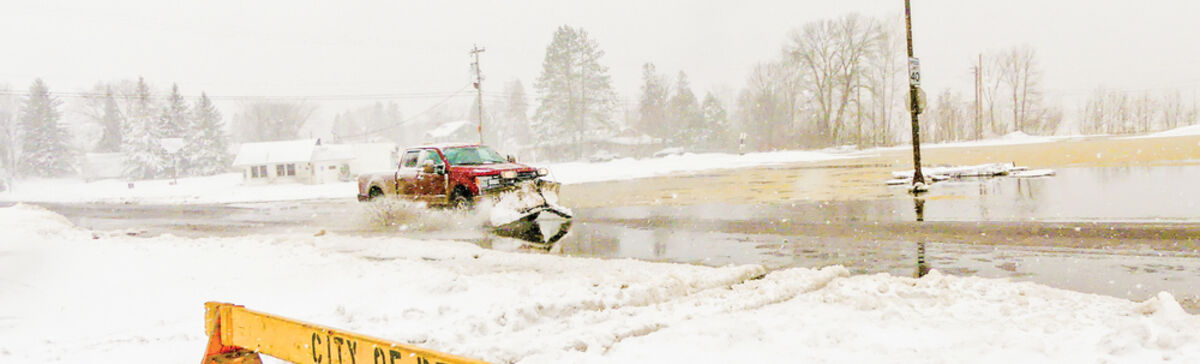
Spring blizzard combines with flooding on Gogebic Range

By P.J. GLISSON

[email protected]

You can always count on an April snowstorm, but the blizzard that hit early this week was more like a weather war between ongoing spring floods and a significant blast of snow.

"I'm pretty sure the consensus around the county is it's not much fun," said Trooper James Rohrer of Michigan State Police Post 87 in Wakefield.

On Monday in that town, Ascherman Street - a north/south byway that parallels the main street - was drifted with snow and blockaded from traffic south of U.S. 2.

Simultaneously, the same street north of U.S. 2 was submerged in water as the south side of Sunday Lake surged over Lake Shore Drive through the area directly west of Krist Food Mart and onto the highway.

As a result, drivers were discouraged from using U.S. 2, but truck traffic continued, albeit at a lower volume than usual.

Throughout Iron, Gogebic and Ontonagon counties, portions of highways and various roadways had been warned as off limits at various times for more than a week.

Already on April 14, Gov. Gretchen Whitmer had declared a state of emergency for Gogebic and Ontonagon counties. "Damages include overwhelmed sewer and storm water systems, burst earthen dams, culvert and embankment failures, and road washouts and closures caused by the accelerated thaw," stated a press release on her behalf.

The blizzard that started on Sunday afternoon and continued until early Tuesday morning then exacerbated the situation.

After the storm, officials shared with The Globe their own perspective on what had happened.

"We had quite a high snow pack on the ground," said Meteorologist Daniel Jablonski of the National Weather Service in Marquette, Michigan. "We also had quite a stretch of unseasonably warm temperatures."

The Gogebic-Iron Wastewater Treatment Facility in Ironwood reported a record high-low for April 12, as the low temperature for that day had never been as warm as 52 degrees. On April 14, the temperature of 78 degrees tied with the high recorded in 1908.

According to Jablonski, the dense snow combined with mild temperatures assured the likelihood of flooding.

Then, he added of the subsequent storm, "We kind of had a low pressure system out west that made its way through."

Because the air already held plenty of moisture, he said the result was a lot of heavy, wet snow. "We had some snow reports of up to nine inches in the western U.P.," said Jablonski of the initial round.

He added that lake effect snow then brought another dump of snow.

Up to 17 inches of snow had been forecast overall with winds up to 45 miles per hour. The NWS also issued a mighty rare warning in this region: "Travel should be restricted to emergencies only."

At 7 a.m. on Monday and Tuesday mornings, the GIWTF in Ironwood reported 8 inches of snow each day, for a total of 16 inches, although the count admittedly varied in each region.

The weather took its toll, with Christine Ouellette of Xcel Energy reporting by phone on Tuesday that a total of nearly 2,200 customers lost power in Wakefield; Marenisco; and Presque Isle, Wisconsin.

Ouellette said that, as officials searched for the problem, ground patrol expanded to flight patrol with the help of a helicopter.

Xcel issued a press release later that day, stating that officials had found an ice-covered conductor that had "sagged into the communication line."

Power was restored to all customers once the issue involving multiple substations was resolved.

Some communities enlisted volunteers in advance of the storm to help fill sand bags to slow down surging water from the Montreal River between Hurley and Ironwood, Little Black River in Wakefield and other waterways.

Multiple directives also were issued on various government websites.

On Sunday, before the blizzard even hit, the city of Wakefield reported "heavy flooding and road closure issues" and stated on its Facebook page, "Please stay home if possible."

Later the same day, the same site requested, "Please avoid travel within the city over the next 24 hours," adding that "treacherous travel conditions" were expected.

Many local governments also warned that local Public Works departments, along with the Gogebic County Road Commission, would restrict snowplowing only to main throughways.

The reasons varied per site and included fears of damaging roads, or even of sinking into them, or inadequate manpower and the distractions of addressing flooding.

Rohrer, at the MSP, commended the GCRC for setting up barriers on local roads as needed. He added that Wakefield needed so many blockades that it was "actually running out of signage" and had to borrow some from Bessemer.

He said that Wakefield's DPW workers also have a pump set up next to the Eddy Park dam, so as to help transfer water from Sunday Lake more efficiently across M-28 to the associate stream moving to the east.

"The dam over there can't keep up with it," he said.

"Wakefield is a big concern because Wakefield is dealing with the most damage," said Deputy Travis Boetto of the Gogebic County Sheriff's Office. But he added, "We've been responding to calls all over the place. People are worried about their houses being damaged."

Gogebic County Sheriff Ross Solberg said he authorized overtime for his deputies in order to help them address flooding concerns.

In Wakefield, City Manager Robert Brown, Jr. said his municipality experienced a number of effects from the recent weather.

Several structures in the area of Charles Street sustained damage, including one that had significant flooding within the basement.

He said a waterline was damaged in the area of Planter Creek by M-28. The resulting leak means that residents on Johnson and Wertanen roads have no drinkable water.

Solberg said his deputies issued notifications to folks in that area and also delivered drinking water to the City Hall for anyone needing it.

Brown also explained that a 2-hour planned power outage took place on Tuesday in order to remove a tree. The targeted area was the intersection of Karling Road and Pierce Street, continuing to the end of Comet Road.

Also in Wakefield, for the third time this year, the city reported on Sunday that it was releasing "highly diluted raw sewage outside the sanitary sewer system to prevent and lessen ...wastewater from backing up into basements."

The city stated that the city's sewer system had become "overwhelmed with surface water" due to general flooding. The resulting discharge - which Brown assured was "clear water" - at U.S. 2 and Putnam Avenue was directed into the stormwater system and Planter Creek while bypassing Sunday Lake.

Andrew DiGiorgio, director of Ironwood's Public Safety Department, said that no serious issues such as power outages or fallen trees have occurred there, nor are they expected.

He explained that the city, historically, always has concerns of rising water in Norrie Park and near the Montreal River in general. But he added, "We've just had some low to moderate flooding."

The Gogebic-Iron Wastewater Authority in Ironwood did issue a notification that a bypass totaling more than 18 million gallons of disinfected effluent had occurred from April 9-17.

"The snowmelt during this period was equal to 9.1 inches of precipitation," said a GIWA release.

Marenisco Township Supervisor Bruce Mahler reported no major problems beyond the power outage explained by Xcel.

During that event, Mahler said that officials there opened the Marenisco Town Hall from 9:30 p.m. on Monday till noon on Tuesday for anyone who needed to warm up, charge a phone, etc.

"We had coffee, water and snacks," said Mahler, who added that the township also released some water from the Presque Isle Dam to relieve pressure there.

He said that Kimberly Road had some water temporarily but was dry as of Tuesday.

Already on April 12, the Iron County Sheriff's Office in Hurley had issued an advisory regarding rising waters.

"Many local municipality roadways are closed due to washouts and roadways being compromised," said the office.

Ontonagon County also issued a press release noting that it had filed a declaration of local emergency.

"Over the weekend, officials drove local roads to assess damage and determine the impact to roads, bridges and culverts," said the report. "Although the situation continues to change due to weather and conditions on the ground, they estimate at least 15 county roads have been impacted in some way." 

"We have two roads closed at the present time with another four that are restricted," stated Ontonagon County Emergency Manager Mike Kocher. "Crews are working to repair road damage and mitigate against further flooding from rivers and culverts, but it won't all happen overnight."

Jablonski, the NWS meteorologist, informed that additional rain and snow is predicted for the rest of this week, with the long-term forecast predicting more next week as well.

However, he assured, that with temperatures expected to be cooler in the near future, "the snowmelt won't be as crazy." And he believes that, as spring then takes a firmer hold, we then can expect a "quiet" period.

For now, Brown is concerned about the onslaught of continuing rain.

"We believe at this time there are several roads that will have significant damage," he said regarding Wakefield.

Boetto, at the Gogebic County Sheriff's Office, agreed, adding that road concerns are not just with passing floods, but with related washouts that could leave more serious road damage even after the water recedes.

Even so, Brown said he and fellow officials are "cautiously optimistic."

As he noted, "I think most of the water in our own troubled areas has receded significantly."

But he added that the city will continue precautions due to "quite a bit" of remaining snow, on top of the expected rain.

Brown said the city will continue pumping Sunday Lake until at least Thursday and will continue releasing diluted sewer water as needed throughout the week.

He expects engineers from Michigan's Department of Environment, Great Lakes and Energy to visit this week to determine the cause of the Planter Creek waterline damage.

And he said that representatives of the Gogebic Emergency Operation Center will continue to operate from the Wakefield municipal building throughout this week.

The emergency declaration from the state, which also includes Houghton County, will bring further help to the general region.

"The declaration of a local state of emergency activates local emergency response and recovery plans," states the governor's press release regarding the emergency status. "By requesting a governor's declaration, these counties have determined local resources are insufficient to address the situation and state assistance is required to protect the health, safety and property to lessen or avert the threat of a crisis."

The report adds, "By declaring a state of emergency, Governor Whitmer has made available all state resources in cooperation with local response and recovery efforts in the designated areas. The declaration provides that the Michigan State Police, Emergency Management and Homeland Security Division (MSP/EMHSD) will coordinate state efforts."

Residents here should monitor local media, weather reports and the Facebook pages of local governments for continuing reports on the regularly changing status of flooding, road closures, and other related issues.

As one example, Wakefield's city Facebook page includes a map showing current or expected flooding.

According to GIWTF, total snowfall for April, as of Tuesday, was 20.5 inches, and total snowfall for the season so far was now 236.1 inches.

That surpasses the 2012-13 total of 223.7 inches but not the 2001-02 count of 263.9 inches.

The 2001-01 count was even higher at 298.1 inches, but the record was in 1996-97 with 301.8 inches. The prior season of 1995-96 had come close with 291.9 inches.